Mobile phones now serve as portable computers, scanners, atlases, cameras, media players, and more. But did you know they’re also part of a growing global mobile sensor network that can garner all kinds of data, such as weather, traffic, and human behavior?
London-based startup OpenSignal released a report today about how the global proliferation of smartphones is leading to the rise of a wide-spread mobile sensor network, calling it “one of the most exciting technological innovations of recent times”:
“Mobile sensor networks present the opportunity to gather data about the world at a never-before-seen scale and low-cost.
Smartphone users participating in crowdsourced mobile sensor networks are able to form part of a social laboratory, acting as gatekeepers of the devices that constantly record data about the environments in which they find themselves.”
In conjunction with the report, OpenSignal has launched a mobile sensors database, which is essentially a library detailing which devices have which sensors, what these sensors are intended for (by the device makers), and how they can be repurposed for other uses.
To better understand how mobile sensor networks operate, and the role smartphones play, let’s take a closer look at what OpenSignal does itself.
Meet OpenSignal
OpenSignal doesn’t always garner the same attention as other London startups such as SwiftKey, Shazam, Hailo, and TransferWise. But the company has been building a powerful arsenal of data over the past five years, thanks chiefly to its eponymous mobile app, which is installed on millions of mobiles around the world.
OpenSignal for Android and, as of fairly recently, iPhone, offers one of the biggest resources for independent data on the speed and network coverage of mobile networks. The app tracks users’ mobile phone coverage across the board, and makes this data available to anyone, so you don’t have to believe what the networks themselves tell you.
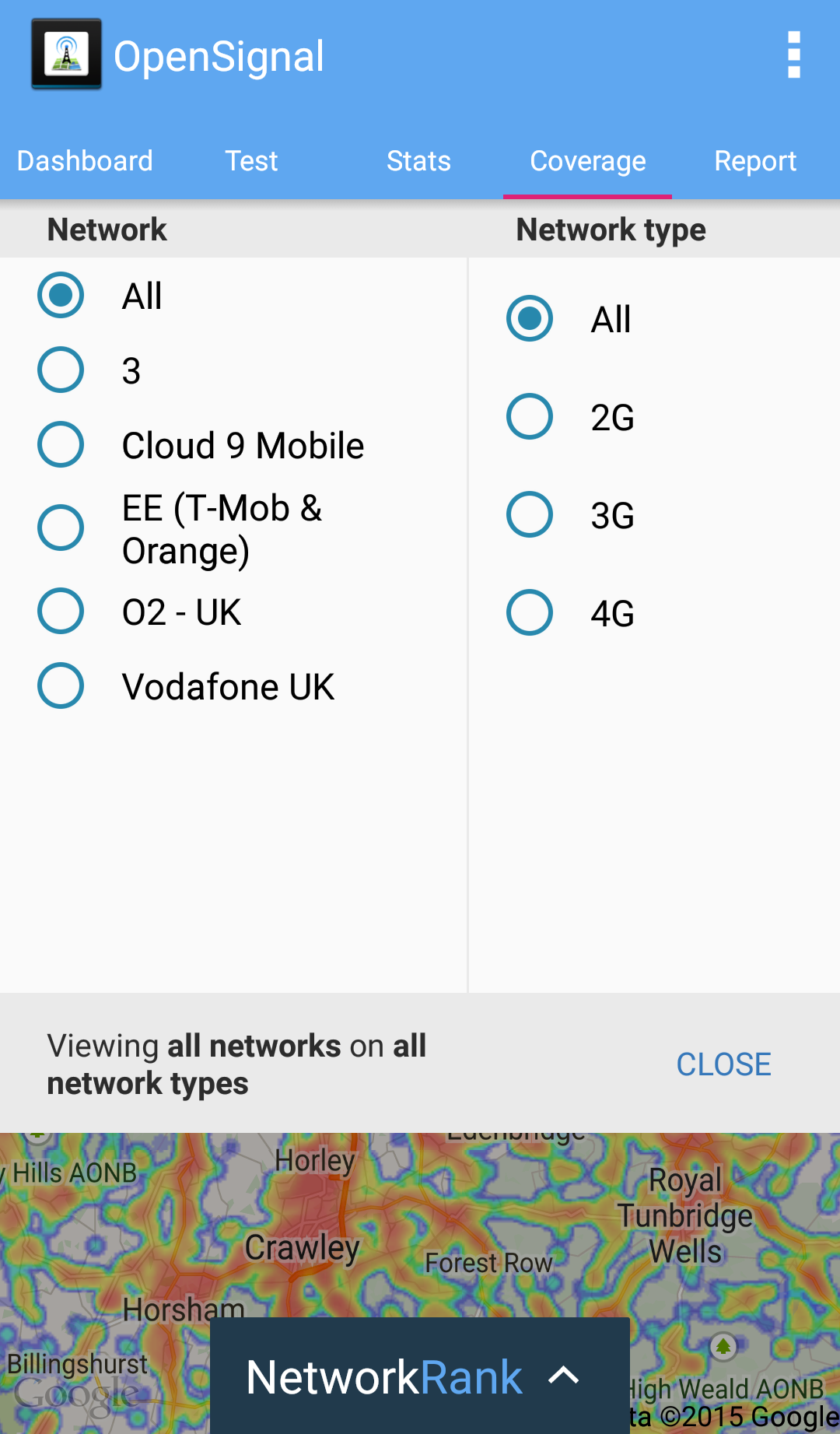
Above: Network Rank
OpenSignal doesn’t just rely on the goodwill of people willing to participate in a giant crowdsourcing exercise. To entice people to download the app, it serves up a multitude of features, including a compass that directs you to where the best wireless signal is, a map that shows public Wi-Fi networks nearby, and a speedtest tool for 3G/4G or Wi-Fi. It also offers a network ranking feature that tells you the best-performing mobile carrier in a specific area.
OpenSignal has also revealed some interesting insights into how consumers can use its data on a more practical level.
For example, some mobile networks promise to cancel a contract or issue a refund if a user doesn’t have a signal, say, 40 percent of the time. But proving that can be tricky — unless you have the data to back things up. Pointing to purely anecdotal evidence, OpenSignal said that some people have used the app to try to wriggle out of contracts.
So OpenSignal gives a lot, and it gets a lot in return. With its app on so many devices, it is able to track other interesting data. For example, it can assess the state of Android fragmentation, revealing that there are almost 20,000 distinct Android devices.
Digging deeper, many mobile phones have sensors installed for very specific reasons related to the functionality of the device. But these sensors can be re-appropriated to garner data on other things.
For example, a phone’s barometer is designed to improve GPS positioning, but it can also be used as a traditional barometer to simply record atmospheric pressure. Then there are built-in light intensity meters to detect screen brightness, but they can also be used to measure sunlight intensity.
Then there are magnetometers, designed to give your phone compass functionality, which can monitor magnetic flux. The exact range of sensors vary from device-to-device, though most modern Android phones have more available than iOS (iPhones).
WeatherSignal
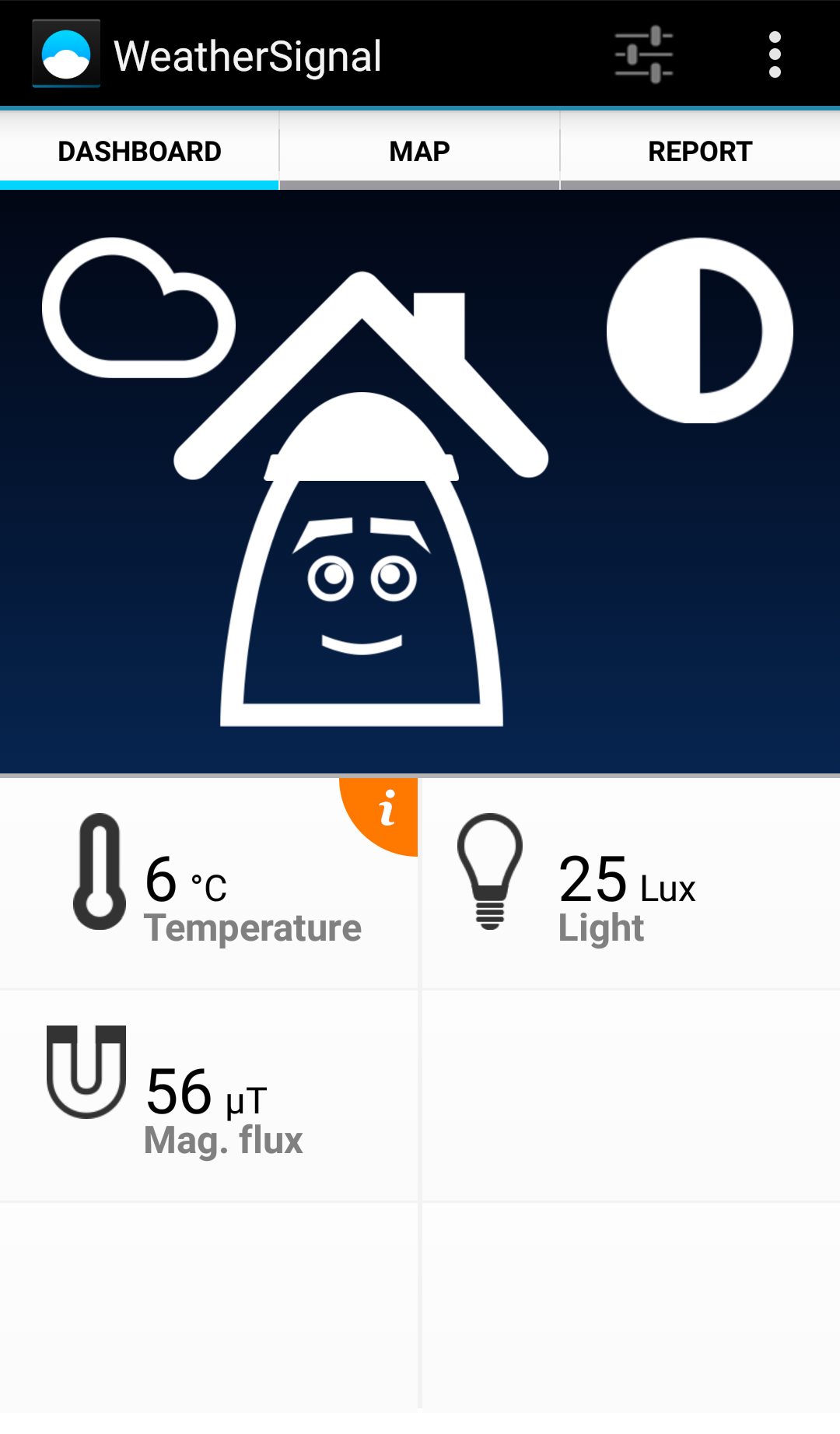
Above: WeatherSignal
OpenSignal realized the potential for all these different sensors and launched a spin-off app in 2013 called WeatherSignal, which is essentially a crowdsourced network of weather forecasts that gathers data passively from people’s phones.
The app is most functional on Android due to the range of sensors. However, with the launch of the iPhone 6 and iPhone 6 Plus, Apple finally included a barometer, meaning WeatherSignal could expand the scope of its coverage into the iOS realm.
There is potential to gather other data from phones too, which isn’t quite perfected yet.
For example, it’s possible to collect temperature from phones that don’t have an external thermometer by using an algorithm to convert battery temperature into environmental “ambient” temperature.
But how can this be reliable if a phone is, say, indoors or even in someone’s pocket? There are workarounds that involve combining sensor readings. For example, if the light readings are below a certain level, then it’s almost certainly not outdoors.
Other clues include not being able to get a GPS fix, which means a phone is more likely indoors. Or if you’re on a Wi-Fi connection, you’re probably indoors. There is a lot of room for error here, but the technology can reach a reasonable degree of certainty by aggregating the data of many different users.
Moreover, future sensors may include things like a colorimeter, which can tell you the temperature of lights and thus distinguish artificial light from daylight.
“We think in the long run, sensors can be used to build this better contextual awareness — are you inside or outside?,” James Robinson, cofounder and CTO of OpenSignal, told VentureBeat. “In the future, it will become more like Google Now, knowing more about your current context. Have you just come in? Have you just gone for a run? Are you with people you know well?”
The ramifications of this are significant: Contextual awareness that goes far beyond the simple latitude/longitude position of a user.
Other players
While mobile sensor networks may present a golden opportunity for crowdsourcing data, OpenSignal’s Robinson reckons this is one area where the hardware is ahead of most developers’ ambitions. “It’s more usual for developers to say something like, ‘I wish I could do this, if only they could make the tools available’,” he said.
In the case of mobile sensor networks, there is still a lot of scope for harnessing what is largely untapped potential. Apple, for example, hasn’t opened up as much as it could to developers. Though OpenSignal launched on iPhone in 2013, it wasn’t able to pull in user data because iOS didn’t allow data to be collected in the background when the app wasn’t running. With iOS 7, that changed, and with enhanced permissions, OpenSignal could finally start tracking data from Apple’s mobile users too.
And as we’ve noted with WeatherSignal, OpenSignal is pretty much restricted to data from the barometer readings on the iPhone 6/iPhone 6 Plus.
“They [Apple] haven’t liberated all the sensor data they could, but in general on Android you’ve got access to so many different sensors,” said Robinson. “However, I don’t think there is too much being done with them.”
Aside from OpenSignal, a number of other companies are working on mobile sensor networks. There’s Sensorly and Rootmetrics in the signal crowdsourcing space, while the likes of PressureNet are operating on the weather side of things. But in terms of a company that’s trying to tackle multiple verticals, OpenSignal pretty much stands alone.
Other companies in the space may not immediately strike you as being sensor networks. Google is perhaps one of the biggest — Google Maps taps millions of GPS locations and correlates them with your cell signal and Wi-Fi hotspots so the next time you use the app, you can get a location fix even without GPS. It’s not a feature, however, it works behind the scenes.
Many mapping platforms also use passive tracking features from apps to improve information on maps — for example, if all cars are moving in one direction on a road, it’s safe to assume it’s a one-way road.
Crowdsourced travel community Waze — now owned by Google — is a good example of how sensor networks are forming. “We’ve observed people like Waze, building up huge crowdsourced networks and having a great success and providing insight that wasn’t possible before,” said Robinson.
There’s a huge hunger to participate in such initiatives around the world, it seems.
“People were downloading Waze even when there was no traffic information in their cities,” said Robinson. “So there was no immediate direct benefit to using it. People just love the idea of being able to participate in research projects, or as part of a crowd, and I think that’s what will drive the next wave of crowdsourced sensor networks.”
It’s easy to forget in amongst all this that OpenSignal is a business. So how does it make money?
$£€
The simple and short answer is that OpenSignal sells data to mobile networks, giving them another view of their network. Carriers spend billions of dollars each year building and maintaining huge wireless networks, so any new perspective they can garner is useful.
These reports are basically PDFs and are often dispatched to C-level execs and then distributed to the network teams. “The data we’re sharing is having an impact, and there are a few success stories of where people have managed to fix problems that they hadn’t realized the network had, based on the data,” said Samuel Johnston, OpenSignal’s marketing manager.
The reports take a general format, with networks able to opt-in to specific niches, such as a city or region, and OpenSignal can show how they compare to their competitors. This could include things like network latency and 3G/4G coverage.
Prior to mobile sensor networks, carriers would basically “drive-test” for the data, physically putting engineers out on the roads to zoom around and check signals in different areas. This was difficult to scale, which is why services such as OpenSignal are vital. OpenSignal also helps surface behavioral habits, such as whether people are opting for Wi-Fi over 3G — drive-testing doesn’t really help with that.
Given the wealth of data OpenSignal holds, the company has had interest from other parties. Since it first started producing Android fragmentation reports a few years back, it has piqued the interest of companies who want a regularly updated index. And there is at least one major Internet company buying these reports, though due to an NDA agreement, OpenSignal isn’t at liberties to disclose who.
But it is worth noting here that OpenSignal gains a more all-encompassing picture of the state of Android than perhaps even Google could, because Google only has access to the “Google Play” Android, not the entire Android ecosystem. Many Android devices in China, for example, don’t use Google Play services. Other companies use “forked” versions of Android, such as Amazon.
But in addition to that, OpenSignal actually tracks more attributes per device, and can tell you, for example, what ARM processors are being used in emerging markets. OpenSignal doesn’t just track device fragmentation, but attribute fragmentation too.
“For each off these attributes, we can look at the market share and how that’s fluctuating,” Robinson explained. “We can say, for example, how many of the devices that shipped in Scandinavia have Bluetooth LE sensors.”
Spin-offs
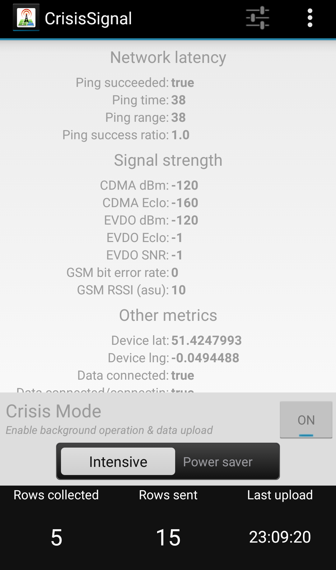
Above: CrisisSignal
We may start to see more spin-off apps from OpenSignal with specific use cases in mind, similar to what it has done with WeatherSignal.
We’re told that it is currently trying to build “the best free-Wi-Fi database in the world,” which users can tap into to instantly find the nearest (and best) free Internet service. While OpenSignal already gathers data on Wi-Fi hotspots around the globe — 400 million and counting — it would require active user input to “tag” locations as free.
There is already another standalone app from OpenSignal out there called CrisisSignal, which is like a real-time version of the main OpenSignal app designed for very specific circumstances — disasters.
It was tested after Hurricane Sandy in 2012 to establish where networks were strongest, and was used to determine where the best places were to set up aid centers.
It’s also being used as part of the Ebola crisis in West Africa. Microsoft cofounder Paul Allen donated 10,000 phones to non-governmental organizations (NGOs) working in the region, and the CrisisSignal app helps inform those NGOs where the best areas are for setting up camps.
State of play


With its newly launched sensor library and report, OpenSignal is hoping to document and summarize the changes that have been happening in the smartphone realm, serving up a little historical context on sensor networks (they’re centuries old) and how mobile phones are giving them a new lease of life.
OpenSignal hopes that people will use the sensor library to look up the different kinds of sensors that are in mobile phones and what portion of devices they’re on. The library could be a useful tool for journalists wishing to know when the first light meter came onto a phone, for instance.
Similarly, a company or developer considering a new app that requires, say, Bluetooth LE, can use the library to find out which devices are Bluetooth LE-enabled — and decide whether it’s worth their while building the app.
OpenSignal is also touting the benefits of sensor networks in an effort to encourage companies to start building their own. “There’s too much stuff for one team to do,” said Johnston.