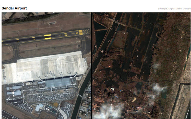
Google said it is working hard to provide the data directly to response organizations on the ground to aid rescue efforts. That’s a new use of satellite imagery, since it is happening so soon after the quake hit, and it allows damage assessments in near real-time. People far away from the region can use the maps to see whether their homes or those of their friends and relatives are still standing.
[aditude-amp id="flyingcarpet" targeting='{"env":"staging","page_type":"article","post_id":248421,"post_type":"story","post_chan":"none","tags":null,"ai":false,"category":"none","all_categories":"business,media,","session":"A"}']If you ever wondered why it would be useful to have instantly updated, real-time satellite imagery, this is clearly the answer.
Google has more information on disaster resources for those in need on a Crisis Response page in English and Japanese. It is also posting updates on Twitter at @earthoutreach. You can view the images in high-resolution by downloading a KML file and exploring it with Google Earth. You can also see imagery in Google Maps or a Picasa album.
AI Weekly
The must-read newsletter for AI and Big Data industry written by Khari Johnson, Kyle Wiggers, and Seth Colaner.
Included with VentureBeat Insider and VentureBeat VIP memberships.
VentureBeat's mission is to be a digital town square for technical decision-makers to gain knowledge about transformative enterprise technology and transact. Learn More
